8 days
")
Cami de Ronda Trail
·
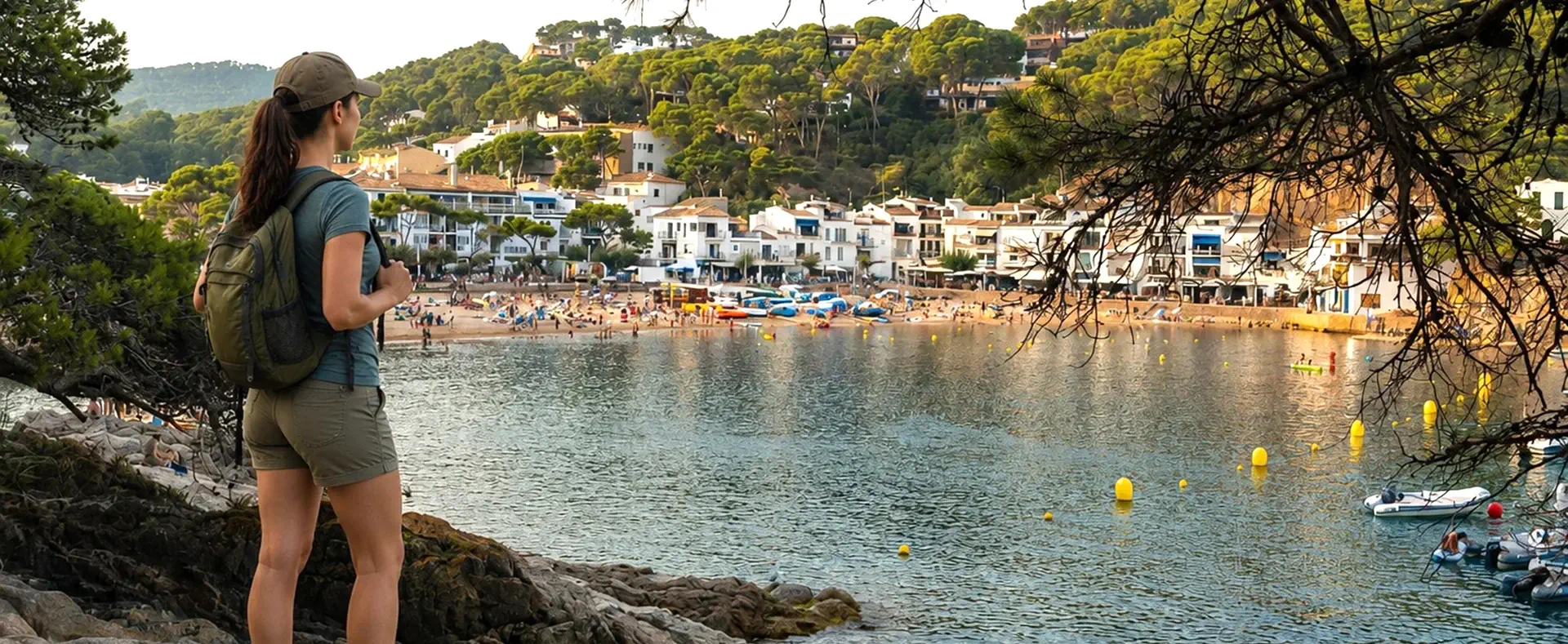
The Camí de Ronda Trail runs along the Costa Brava coastline from Figueres to Palamós, winding between rugged cliffs, crystal-clear coves and fishing villages such as Cadaqués, Begur and Palafrugell. Among Mediterranean pine forests and views of the Mediterranean Sea, this route combines wild landscapes and fishing heritage in a unique and unforgettable experience.
▸ Includes
")
from 840 €
")
11 days
Cami de Ronda Trail
·
From Figueres, the trail hugs cliffs and hidden coves along the Camí de Ronda trail until reaching Sant Feliu de Guíxols. The cliffs that follow on the stretch passing through Tossa de Mar to Blanes offer countless secluded coves of singular beauty with pines at the edge of the sea.
▸ Includes
")
from 996 €


Stay in charming hotels
We choose charming accommodations, in areas away from conventional tourism but with a genuine atmosphere

Spectacular routes
Walking along the Empordà coastline and discovering medieval inland villages
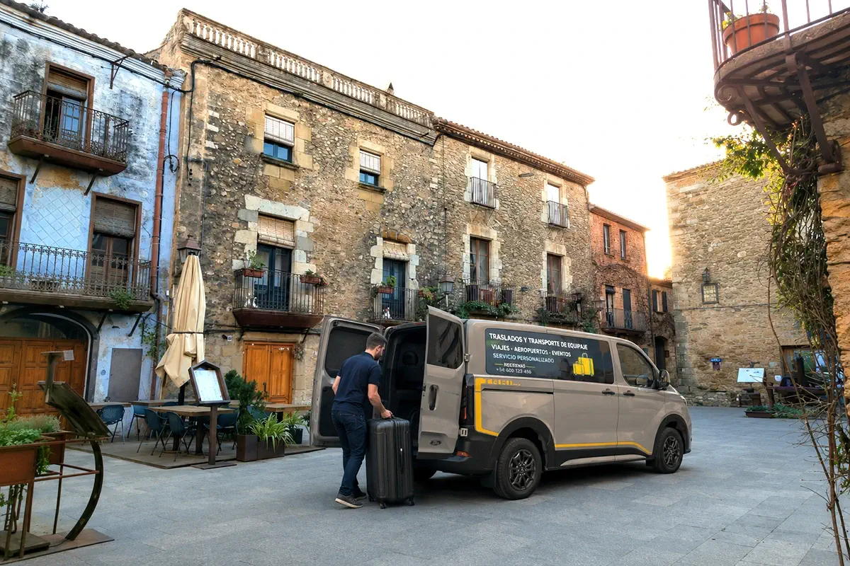
Luggage transfers
Forget about your luggage and walk comfortably. We move it from accommodation to accommodation.

GPS navigation
Through our app you will be able to follow the route layout without fear of getting lost. Includes cartography and information.

Natour reviews and comments on Google
What do customers say about us?
Questions?
We are here to assist you and ready to clarify any doubts. Ask me anything you wish!
")
a different itinerary?
If you plan to do the Camí de Ronda Trail starting in Portbou and ending in Blanes, ask us for a program tailored to your convenience.
We offer you the best price and the best conditions
REQUEST MORE INFORMATION
…frequently asked questions
How does the luggage transfer between hotels work on point-to-point itineraries?
You must leave your suitcase at the hotel reception in the morning (usually before 8:00 or 9:00 AM). The company picks it up and delivers it to your next accommodation before you arrive on foot.
Is there a weight or size limit for the suitcase being transferred?
Yes, the standard is one suitcase per person of about 15-20 kg. If you carry more pieces, there is usually a surcharge.
Can I leave valuables in the suitcase being transferred?
It is recommended to always carry money, documents and delicate electronics with you in your day pack. The transfer is safe, but the suitcases pass through several hands and transports.
What happens if my suitcase doesn't arrive on time at the next hotel?
We have a 24/7 assistance phone to locate the transport and solve any logistical incident immediately.
To do each itinerary, do I need to know how to use a paper map or compass?
It is not essential if you use our agency’s app, but it is always advisable to know how to interpret a physical map. The app will guide you through your phone’s GPS.
Does the application work in areas without data coverage?
Yes. Our app provides you with a flow of information and maps that you download in advance so they work completely offline, allowing you to see your exact position on the track even in high mountains.
What happens if I run out of battery on my phone during the route?
This is the main risk. That is why it is mandatory to carry a charged external battery (powerbank) and to carry the printed stage technical sheets as a backup.
Are the GPS tracks accurate?
Yes, they are usually recorded on the ground and updated periodically to avoid closed trails or recent route changes.
What type of accommodations are included in these itineraries?
It depends on the package, but typically hotels, rural houses or guesthouses with private bathroom and quality standards verified by our agency.
Are dinners included?
Generally, breakfast is always included. Some accommodations offer dinner (half board) or “picnic” for lunch on the route, which you must arrange separately.
Can they cater for special diets (celiac, vegan)?
Yes, as long as advance notice is given, the agency coordinates with the accommodations so that they adapt the menus.
What happens if one day I feel unwell or am too tired to walk?
In this case we can arrange a taxi transfer (at extra cost or included depending on the insurance) to the next hotel so you can rest.
What is the difficulty level of the routes?
The routes are categorized by elevation gain and distance. Based on the chosen itinerary, we will advise you on which one best suits your physical condition before making the reservation.
Is it safe to do the route alone?
Yes, thanks to GPS tracking and the assistance phone. You are “alone but connected”. In addition, on popular routes you will always find other hikers.
How can I share my trip with another person?
There are applications such as GAFFL that make it easy for you to connect with other “solo travellers” with whom you could share your trip. Sharing your trip with another person has many advantages:
- Economy: the price of your trip will be cheaper as you split the costs of accommodation and transfers with another person
- Environment: you contribute to the sustainability of the planet
- Social: You share experiences while discovering new sceneries.
How will I receive my trip documentation?
A few weeks before starting your trip, you will receive the user manual of the app and access data, as well as hotel vouchers and gear recommendations.
When you arrive at the first accommodation, you will find an envelope for you with a physical map and luggage tags to properly identify the suitcases we will need to transport.
Cami de Ronda Trail: The Ultimate Costa Brava Coastal Adventure
Introduction to a Mediterranean Masterpiece
The Mediterranean coast of Catalonia holds one of Europe’s most breathtaking secrets, and that is the Cami de Ronda Trail. Stretching along the rugged, sun-drenched Costa Brava, this legendary coastal pathway offers travelers an unparalleled blend of dramatic cliffs, turquoise waters, hidden coves, and charming medieval villages. For anyone looking to truly connect with the raw beauty of the Spanish coastline, embarking on the Cami de Ronda Trail is an absolute must.
Originally designed centuries ago for practical and defensive purposes, the modern incarnation of the Cami de Ronda Trail is now celebrated worldwide as a premier hiking destination. It caters beautifully to nature lovers, hardcore trekker enthusiasts, and casual walkers alike. Whether you tackle a short afternoon section or commit to a multi-day trek, the Cami de Ronda Trail promises unforgettable vistas and an authentic taste of the Mediterranean lifestyle.
The Historical Roots of the Footpath
 To truly appreciate the unique layout of the Cami de Ronda Trail, one must dive deep into its rich and fascinating history. The origins of the Cami de Ronda Trail date back to times when local authorities, fishermen, and coastal watchmen needed a reliable network of paths to navigate the sheer, rocky cliffs. The word “ronda” literally translates to the patrols or “rounds” made by royal guards, and later the Spanish Guardia Civil, who utilized the Cami de Ronda Trail to control maritime smuggling.
During the 19th and 20th centuries, contraband was rampant along the fragmented geography of the Costa Brava. Tobacco, alcohol, coffee, and luxury goods were frequently brought ashore under the cover of darkness. Walking the Cami de Ronda Trail today feels like stepping back into a spy novel, as you retrace the exact footsteps of the guards who scanned the horizon for illicit vessels. Over the years, as smuggling faded, local governments recognized the recreational potential of the Cami de Ronda Trail, transforming a defensive military route into a beautifully maintained public pathway.
Deconstructing the Route: Southern Majesty
Geographically, the entire network spans over 200 kilometers, stretching from the bustling resort town of Blanes up to the French border town of Portbou. Because this distance is vast, the Cami de Ronda Trail is typically enjoyed in distinct segments. The southern section of the Cami de Ronda Trail begins in Blanes, which serves as the official gateway to the wild coast.
From Blanes, hikers on the Cami de Ronda Trail are treated to stunning views of botanical gardens like Marimurtra, perched dramatically over cliffs. Moving forward toward Lloret de Mar, the path challenges walkers with steep stone staircases and dark tunnels carved directly into the rock. This specific portion of the Cami de Ronda Trail perfectly showcases how human engineering can blend harmoniously with wild nature. The reward at the end of this stretch is arriving at the stunning medieval walled town of Tossa de Mar, where the ancient stone fortifications overlook the golden sands.
The Heart of the Costa Brava: Central Wonders
Many experienced hikers consider the central stretch between Sant Feliu de Guíxols and Begur to be the crown jewel of the Cami de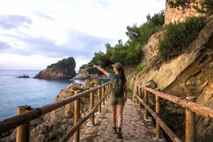 Ronda Trail. In this region, the Cami de Ronda Trail transitions into a showcase of elegant coastal architecture and pristine natural beauty. Near S’Agaró, for instance, the path turns into a wide, beautifully paved promenade designed by visionary architects, making this part of the Cami de Ronda Trail accessible to families and casual strollers.
As you push further north, the Cami de Ronda Trail dives deep into dense pine forests whose sweet scent mixes with the salty sea breeze. This section leads directly into iconic fishing villages such as Calella de Palafrugell and Llafranc. Hiking along the Cami de Ronda Trail in this area gives you the unique opportunity to descend into hidden, rocky coves (locally known as *calas*) that are entirely inaccessible by motorized vehicles. The sheer exclusivity of these spots makes the Cami de Ronda Trail an incredibly rewarding experience for adventurers seeking solitude and pristine waters.
The path reaches a scenic peak around the hilltop town of Begur. Here, the Cami de Ronda Trail weaves through dramatic cliffs to reveal world-famous, postcard-perfect beaches like Cala Sa Tuna, Cala Aiguablava, and Platja Fonda, each boasting a distinct shade of crystalline blue water.
The Wild North and the Surrealism of Dalí
As the route ventures further north into the Alt Empordà region, the environment changes dramatically. The northern reaches of the Cami de Ronda Trail cross the wide Gulf of Roses, passing by the fascinating Greco-Roman archaeological ruins of Empúries. Continuing onward, the Cami de Ronda Trail enters the bohemian enclave of Cadaqués, a whitewashed village that has captivated artists for generations.
Beyond Cadaqués, the Cami de Ronda Trail introduces hikers to the raw, wind-swept landscapes of the Cap de Creus Natural Park. In this protected area, the Cami de Ronda Trail showcases surreal rock formations sculpted over millennia by the fierce Tramuntana wind. These bizarre, animal-like stone shapes heavily inspired the works of Salvador Dalí. Walking the Cami de Ronda Trail through Cap de Creus feels like traversing an extraterrestrial world, where the dark, volcanic rock collides violently with the churning, deep-blue Mediterranean Sea.
Biodiversity and the Mediterranean Climate
The environmental richness encountered throughout your journey is a major highlight. The entire Cami de Ronda Trail serves as a living museum of Mediterranean flora and fauna. Walkers are constantly accompanied by the therapeutic aromas of wild rosemary, thyme, Aleppo pines, and robust holm oaks that cling stubbornly to the cliff faces.
In terms of climate, the region experiences warm, dry summers and wonderfully mild winters. While summer is perfect for combining hiking with frequent swimming stops, spring and autumn provide the ideal temperatures for long-distance walking. Choosing the right season to experience the Cami de Ronda Trail can significantly enhance your comfort, allowing you to enjoy the outdoors without the intense mid-July heat.
Practical Tips for an Unforgettable Trek
Planning a successful journey requires mindful preparation. While parts of the route are gentle, other segments require a good level of fitness and proper equipment.
▸ Footwear: Sturdy trail-running shoes or hiking boots are essential due to loose gravel.
▸ Hydration: Always carry plenty of water, especially during the hot summer months.
▸ Navigation: Follow the red and white (GR-92) or local green and white trail markers.
By respecting the local guidelines, you help preserve the delicate ecosystem surrounding the Cami de Ronda Trail. Whether you decide to explore a tiny fragment or brave the entire distance, the magic of the Cami de Ronda Trail will undoubtedly leave an indelible mark on your soul, drawing you back to the shores of the Costa Brava time and time again.