Pilgrimage Routes

CAMINO DE SANTIAGO

The Camino de Santiago: An Age-old Pilgrimage
camino


The Camino de Santiago represents one of the most important pilgrimage routes in the Christian world, a cultural and spiritual phenomenon that has endured through the centuries and has experienced an extraordinary renaissance in recent decades. This ancient pilgrimage route, which has as its final destination the cathedral of Santiago de Compostela in Galicia, where, according to tradition, the remains of the apostle Santiago the Greater lie, has transcended its purely religious dimension to become a transformative experience that attracts people of diverse beliefs, nationalities and motivations.

History and Origins

Did you know that the history of this beautiful tradition dates back to the 9th century? According to tradition, in the year 813 a hermit called Pelayo discovered a tomb in the forest of Libredón (which today is Santiago de Compostela) that was attributed to the apostle Santiago el Mayor. The news reached King Alfonso II of Asturias, who became the first pilgrim to visit the site and ordered the construction of a small church. This discovery, considered miraculous, coincided with a period when the Iberian Peninsula was mostly under Muslim rule, so the discovery acquired an important symbolism for Christian resistance and became a powerful element of cohesion for the Christian kingdoms of the north.

During the 10th and 11th centuries, the pilgrimage to Santiago began to gain international relevance. It was then that the kings Sancho III of Navarre (1004-1035) and Alfonso VI of Castile and León (1065-1109) decided to improve the pilgrimage routes, creating hospitals, bridges and hostels. What a good idea! The Cluny order, which was the driving force behind the monastic reform throughout Europe, also helped the Camino to become bigger, as it was responsible for setting up monasteries along the route. The first foreign pilgrim we know of was Godescalco de Le Puy, a bishop who made the pilgrimage in 950.

And, in case you were wondering, the Codex Calixtinus, which was compiled around 1140 under the patronage of Pope Callixtus II, is considered the first guidebook. The fifth book, written by the French cleric Aymeric Picaud, takes us through the route from France, its monuments and local customs, and provides practical advice for pilgrims, thus establishing the main itinerary known today as the French Way. What an exciting adventure awaits all of us who decide to follow in its footsteps!

The Middle Ages marked an unprecedented milestone with the pilgrimages to Santiago de Compostela. Thousands of pilgrims from all over Europe travelled the Camino every year, which undoubtedly contributed to an intense cultural, artistic and commercial exchange. Romanesque churches, Gothic cathedrals, hospitals and hostels were built, forming an exceptional architectural heritage. This itinerary undoubtedly became a real backbone of medieval Europe, a channel for the transmission of ideas, artistic styles, literature and music.

However, from the 14th century onwards, various factors such as the Black Death, wars and later the Protestant Reformation caused a decline in pilgrimages. For centuries, it maintained a discreet existence, reduced to a largely local or national phenomenon, until its revival began in the 20th century.

camino
pilgrimage

The Camino de Santiago came back into fashion in the 1980s, thanks to the interest of researchers, the work of the Friends of the Way clubs and the support of institutions. A key moment was when Pope John Paul II visited Santiago in 1982 and called on Europe to return to its Christian roots. In 1987, the Council of Europe said that the Camino de Santiago was the First European Cultural Itinerary and, in 1993, UNESCO added the French Way in Spain to the World Heritage list, and in 2015, it also included the Pilgrims’ Routes to Santiago del Norte.

Cultural and Spiritual SignificanceThe route goes beyond its original religious significance and becomes cultural, spiritual and social with many meanings. Although it started out as a Christian pilgrimage route, today it is used by people from all walks of life.

For Catholics, it remains a religious pilgrimage, an act of devotion to the apostle Santiago and an opportunity for spiritual renewal. Arriving at the cathedral of Santiago, going to the Pilgrim’s Mass and embracing the image of the saint are the highlights of a journey of faith.

But for many, it is something more personal, a way of finding oneself and growing, even if one is not religious. The simplicity of life on the Camino, reduced to walking, eating and resting, makes it a good time to think, to get to know oneself and to evaluate what is really important in life. Many people who do the Camino say that it is a journey of personal transformation.

The cultural aspect of the Camino is undoubtedly relevant. The route crosses regions with an undoubtedly rich historical and artistic heritage, allowing pilgrims to discover Romanesque, Gothic and Baroque monuments, local traditions, regional gastronomy and diverse landscapes. The Camino, more than a route, is a thread that weaves together a valuable necklace of cultural manifestations.

The social dimension is another of its fundamental aspects. The coexistence in the hostels, the chance encounters during the walk and the experiences shared with people of different nationalities and social conditions create an atmosphere of temporary community that many pilgrims particularly value. This community spirit is reflected in the solidarity between pilgrims and in the hospitality of the local populations.

▸ Incluye

The Camino Primitivo

The Camino Primitive, considered the original pilgrimage route to Santiago, was the itinerary followed by King Alfonso II of Asturias in the 9th century, when he travelled from Oviedo to verify the discovery of the tomb of the apostle St. James. For this reason, it is given the title of ‘first pilgrimage’.

This route, which has been travelled by pilgrims since medieval times, begins in the city of Oviedo, where pilgrims used to visit the Cathedral of San Salvador and its relics, following the popular saying: ‘he who goes to Santiago and not to the Saviour, visits the servant and not the Lord’. From there, the route heads westwards, crossing the inland mountains of Asturias and Lugo, until it joins the French Way at Melide, some 50 kilometres from Santiago de Compostela.

peregrinacion
camino

Get a quote

    By submitting this form, you confirm that you have read and understood ourPrivacy Policy - Terms & Conditions, accepting the use we make of your information.

    With an approximate length of 325 km, the Camino Primitivo is one of the shortest routes, but also one of the most physically demanding due to its mountainous profile, with numerous ascents and descents, especially in its Asturian section. Pilgrims who are in good physical shape and who crave a challenge are suggested to consider this route, which offers the possibility of delighting in the serenity and charms of the natural landscapes.

    The route offers the opportunity to immerse yourself in the authenticity of rural Spain, passing through small villages, native forests, pastures and mountains. The stretch between Oviedo and Lugo, in particular, is renowned for its beauty, with mountain views, traditional architecture and gastronomy based on local produce.

    The Camino Primitive has experienced a notable increase in popularity in recent years, although it is still less travelled than other routes such as the French Way or the Portuguese Way. There has been a notable improvement in the accommodation infrastructure for pilgrims, with the presence of public and private hostels in most of the stages, although in some sections there can be considerable distances between accommodation.

    This route offers a more authentic experience, closer to the original spirit of pilgrimage, with a strong component of introspection facilitated by the natural surroundings and less overcrowding. In addition, this route is particularly suitable for the summer months, as its wooded sections and higher altitude offer cooler temperatures.

    ▸ Incluye

    The Camino Inglés

    The Camino Inglés, as it is known, owes its name to the pilgrims from England, Ireland and Nordic countries who arrived by sea at the Galician ports of Ferrol or A Coruña, and then continued their pilgrimage on foot to Santiago de Compostela. This maritime-terrestrial route reached its peak of popularity during the Middle Ages, when the French Way became unsafe due to political turbulence, and experienced renewed interest in the 14th and 15th centuries.

    At present, the Camino Inglés has two possible starting points: From Ferrol: This route, which extends over approximately 116 km, allows the Compostela to be obtained by passing the minimum 100 km required. The route is usually completed in 5-6 stages.
    From A Coruña: This pilgrimage route is shorter, at approximately 75 km, which means that, technically, it does not meet the 100 km requirement to obtain the Compostela. However, the Pilgrim’s Office can grant exceptions to pilgrims who can prove that they have completed a stage in their country of origin.

    pilgrimage
    peregrinacion

    Get a quote

      By submitting this form, you confirm that you have read and understood ourPrivacy Policy - Terms & Conditions, accepting the use we make of your information.

      The two variants converge harmoniously in the town of Bruma, from where they unfold in a shared route towards Santiago de Compostela. The route crosses the regions of Ferrolterra, A Coruña and Santiago, allowing you to get to know both coastal and inland Galicia.

      The Camino Inglés, characterised by its brevity, is particularly suitable for those who have limited time available for pilgrimage or who wish to have a first experience of the Camino de Santiago. Despite its brevity, it offers a rich variety of landscape and culture, with urban, coastal and rural sections, as well as a valuable historical heritage.

      In recent years, it has experienced a notable increase in popularity, although it is still less travelled than other routes. However, there has been a significant improvement in the infrastructure of hostels, with the presence of accommodation on practically all stages of the route. The Camino Inglés offers a quieter and more secluded experience than other routes, with less traffic even in high season.

      In addition, it is important to highlight its connection with the Jacobean tradition in Anglo-Saxon and Nordic countries, which adds a touch of diversity and cultural richness to this spiritual route. In recent years, initiatives such as the ‘Celtic Way’ have been implemented in Ireland, which offers pilgrims the possibility of walking stages in their country of origin before continuing their journey to Galicia to complete the Camino, thus respecting the original essence of this pilgrimage route.

      ▸ Incluye

      The Vía de La Plata

      The “Vía de la Plata” (Silver Route), a Jacobean pilgrimage route of great historical and cultural importance, is the longest and oldest in Spain, running through the country from south to north. Its name is not related to the precious metal, but derives from the Arabic term ‘balata’ (cobbled road), in reference to the ancient Roman road that connected Emerita Augusta (Mérida) with Asturica Augusta (Astorga).

      This historic route, which was initially used by the Romans for military and commercial purposes, later became an important pilgrimage route for Christians from the south of the Peninsula who longed to reach Santiago de Compostela. The Vía de la Plata, a route of great historical and cultural significance, traditionally begins in the city of Seville, although it is possible to start some variants in Cádiz or Huelva. This emblematic route crosses the autonomous regions of Extremadura, Castile-León and Galicia, uniting ancient traditions and cultures.

      With an approximate length of 1,000 km from Seville to Santiago, this route represents a considerable challenge that usually requires between 40 and 45 days to complete. From Astorga, pilgrims have the option of continuing along the French Way or taking the variant known as the Camino Sanabrés, which heads to Santiago via Puebla de Sanabria and Ourense.

      peregrinacion
      camino

      Get a quote

        By submitting this form, you confirm that you have read and understood ourPrivacy Policy - Terms & Conditions, accepting the use we make of your information.

        The Vía de la Plata offers an extraordinary diversity of landscape and culture, ranging from the warm lands of Andalusia and Extremadura to the Castilian moors and Galician mountains. It is worth mentioning that the climatic contrast is notable, with extremely hot summers in the southern stretches, which makes it advisable to avoid the months of July and August for these stages.

        With regard to the infrastructure for pilgrimages, it is important to note that, although improvements have been made in recent years, the Silver Route still has a less extensive network than the French Way. It is important to bear in mind that some stages may be considered long and that services may be limited, which requires careful planning. This characteristic, far from discouraging, helps to preserve the sense of adventure and discovery that characterises this route.

        This route is particularly attractive to experienced pilgrims who seek a significant physical challenge, value solitude and silence, and show an interest in the history, archaeology and cultural diversity of Spain. The Vía de la Plata offers a deep immersion in different ecosystems, traditions and gastronomies, making it much more than a route to Santiago: it is a journey through the essence and history of the Iberian Peninsula.

        ▸ Incluye

        Camiño dos Faros

        The Camiño dos Faros winds like a silvery thread along the Galician Costa da Morte, where the Atlantic fiercely and tenderly kisses the land that welcomes it. This 200-kilometre trail that links Malpica with Finisterre is not just a hiking route; it is a vital experience that awakens all the senses and shakes the soul of the walker.

        From Malpica, the path plunges into a world of contrasts. The waves break furiously against the rocks of Roncudo, where goose barnacles defy death in search of their prized delicacy. Further on, the calm waters of Traba beach offer a respite before the path enters the green valleys that lead to Laxe and Camariñas, where the light of the lighthouses guides the sailors on stormy nights.

        When the pilgrim finally reaches the Finisterre Lighthouse, with tired legs but renewed spirit, he understands that the Camiño dos Faros is not just a path linking lighthouses, villages and beaches. It is a metaphor for life itself: a path of discovery where external landscapes reveal internal landscapes, where each step on the ground is a communion with something greater than ourselves.

        Get a quote

          By submitting this form, you confirm that you have read and understood ourPrivacy Policy - Terms & Conditions, accepting the use we make of your information.

          The Camiño dos Faros is a magical journey along the coast of Galicia, a path of light and salt where the land melts into cliffs and the ocean whispers ancient stories. Along its approximately 200 kilometres, it links Malpica with Finisterre, weaving together landscapes of untamed beauty, between solitary beaches, moving dunes, serene estuaries and mountains that look out over the Atlantic with the nostalgia of those who have seen countless boats depart with no promise of return.

          The path winds its way between steep cliffs that plunge towards an ocean of such intense blue that it seems unreal. In the distance, the lighthouses – centuries-old guardians of the coast – emerge as silent witnesses to sea tragedies and sailors’ hopes. The Vilán lighthouse, with its white tower defying the storms, looks like a finger pointing to the sky in search of answers that only the sea knows.

          On the stretches where the route goes briefly inland, the pine and eucalyptus forests offer their protective shade. The scent of the damp earth mingles with the perfume of the wild flowers that carpet the meadows in spring, creating an olfactory symphony that intoxicates the senses.

          The beaches that punctuate the route are poems written in sand. Some, like that of Trece, extend generously inviting you to rest; others, like small coves hidden among rocky formations, seem like secrets that the sea only shares with those who dare to look for them.

          The fishing villages that the Camiño passes through are relics of a time when man and sea maintained a constant dialogue. In Camariñas, the palilleiras weave lace with the same delicacy with which the waves shape the coast. In Laxe, the coloured boats rest on the sand like exotic birds that have decided to take a rest.

          ▸ Incluye

          Trilho dos Pescadores

          The Trilho dos Pescadores is one of the most impressive coastal walks in Portugal. Part of the Rota Vicentina, this hiking route winds along the Alentejo and Algarve coastline, offering walkers a unique experience between steep cliffs and unspoilt beaches.

          stretches over approximately 226 kilometres, divided into 13 stages connecting Porto Covo in the Alentejo region to Cape St. Vincent in the Algarve. The route largely follows the trails used by local fishermen to access the best fishing spots and is characterised by its proximity to the sea, with stretches that skirt the cliffs and others that descend to hidden coves of golden sand.

          Get a quote

            By submitting this form, you confirm that you have read and understood ourPrivacy Policy - Terms & Conditions, accepting the use we make of your information.

            Each stage of the Trilho dos Pescadores offers a different experience. The first part of the route, from Porto Covo to Vila Nova de Milfontes, stands out for its dreamy beaches and landscapes dominated by coastal dunes. As you head south, the trail enters the Natural Park of Southwest Alentejo and Costa Vicentina, a protected area that is home to a unique biodiversity, with seabirds such as the shag and the white stork, which nests on the cliffs, a rare phenomenon in Europe.

            One of the most impressive sections of the route is the one connecting Almograve to Zambujeira do Mar, where the cliffs become steeper and offer unforgettable views of the ocean breaking against the rocky coastline. In Zambujeira do Mar, walkers can enjoy a welcoming atmosphere, with restaurants serving fresh fish and seafood, reflecting the region’s fishing tradition.

            As the trail enters the Algarve, the vegetation changes slightly, giving way to more arid landscapes and a greater presence of Mediterranean scrub. The final stretch of the Trilho dos Pescadores culminates at the iconic Cabo de São Vicente, a place of great historical and cultural value, where ancient navigators believed the world ended. Here, the immensity of the ocean and the strength of the wind create an almost mystical atmosphere, perfect for closing the journey with a moment of reflection and connection with nature.

            Accommodation along the route is varied, ranging from backpacker hostels to small charming hotels. Many establishments offer specific services for hikers, such as luggage transport between stages or up-to-date information on trail conditions.

            This hiking itinerary represents an unparalleled opportunity to connect with the wild nature of the Portuguese coast, to discover a cultural heritage rooted in seafaring traditions and to experience Portuguese hospitality at its most authentic.

            ▸ Incluye

            Picos de Europa

            In the heart of the Cantabrian Mountains, the Picos de Europa are one of Spain’s most impressive mountain landscapes. This massif, shared by the regions of Asturias, Cantabria and Castile-León, offers endless hiking routes through deep valleys, rocky peaks and charming villages. On the Asturian side, the Picos de Europa National Park is a real paradise for nature and adventure lovers, with routes for all levels, from gentle walks to demanding ascents.

            One of the most emblematic routes is the one that starts at the sanctuary of Covadonga and leads to the famous lakes Enol and Ercina. This itinerary combines the natural and scenic value with the historical and religious importance of the place. The ascent to the lakes, accessible both by car and on foot, offers spectacular views of the mountains and, with luck, of cattle grazing in the wild. From the lakes there are several trails that take you deeper into the heart of the park, such as the one that leads to the Mosquital peak or to the Vega de Ario.

            Get a quote

              By submitting this form, you confirm that you have read and understood ourPrivacy Policy - Terms & Conditions, accepting the use we make of your information.

              Another very popular route is the Ruta del Cares, a path carved into the rock that links the villages of Cain (León) and Poncebos (Asturias). For about 12 kilometers, the trail winds between vertical walls and gorges, following the course of the Cares River. This route, also known as “the Divine Gorge”, is one of the busiest in the park for its breathtaking beauty and accessibility. Although the slope is moderate, it is important to wear appropriate footwear and be cautious, as in some sections the path is narrow and unprotected.

              For the most experienced climbers, the ascent to the Naranjo de Bulnes (or Picu Urriellu) is a unique experience. This limestone colossus is one of the symbols of the Picos de Europa and a challenge for climbers. Although climbing is not required to approach the Vega de Urriellu refuge, the route that starts from the village of Sotres or from Pandébano involves considerable physical effort. However, the effort is rewarded by the majesty of the surroundings and the proximity to one of the most iconic mountains of the peninsula.

              The Asturian villages surrounding the park, such as Cangas de Onís, Arenas de Cabrales or Sotres, complete the experience with their hospitality, rich gastronomy and traditional architecture. After a day of hiking, there is nothing better than recharging your batteries with a plate of Asturian bean stew or a piece of Cabrales cheese.

              In short, the routes through the Picos de Europa in Asturias are an invitation to discovery and amazement. Each step reveals a new corner, an unforgettable view or a silence that can only be found in the mountains. Whether for a one-day getaway or a journey of several days, this place keeps the purest essence of Asturian nature.

              Camiño dos Faros

              camino

              If you will allow me to observe, on a symbolic level, it could be said that it represents a physical journey that is also, in a certain sense, an inner journey. The daily effort, the overcoming of difficulties, the contact with nature and the stripping of the superfluous acquire a metaphorical value that transcends the simple activity of walking. As with any pilgrimage, the Camino de Santiago represents a ritual of transition, a parenthesis in daily life that allows one to return transformed.

              In today’s fast-paced, digitally hyper-connected context, the Camino offers an opportunity to disconnect, slow down and reconnect with the fundamental aspects of human existence. Walking for days or weeks at a leisurely pace, in contact with nature and with oneself, represents a valuable counterpoint to prevailing lifestyles.

              camino
              camino

              The Camino Portugués in Spain

              The Portuguese Way, in its Spanish section, comprises the last 110 kilometers of the route that starts in Lisbon and enters Galicia through Tui, following the course of the Miño River. This route is currently the second most traveled route after the French Way.

              The history of the Portuguese Way is closely linked to the independence of Portugal as a kingdom in the 12th century. Devotion to the apostle St. James was very intense in Portugal, where numerous churches and towns bear his name. Portuguese kings, nobles and religious figures made frequent pilgrimages to Compostela over the centuries.The Portuguese Way, in its Spanish section, comprises the last 110 kilometers of the route that starts in Lisbon and enters Galicia through Tui, following the course of the Miño River. This route is currently the second most traveled route after the French Way.

              The Spanish section of this route runs through the Galician regions of Baixo Miño, Condado, Pontevedra and Santiago, largely following the ancient route of the Roman Via XIX that linked Braga with Astorga. The route is generally smooth, with slight undulations, except for some occasional climbs, which makes it physically less demanding than other routes.

              The Portuguese Way offers the pilgrim an impressive cultural richness, an exceptional gastronomy based on the products of the sea and the orchard, and landscapes that alternate between estuaries, river valleys and cultivated areas.

              The infrastructure is highly developed, with public and private hostels in all the main stages, as well as a wide range of accommodations of various categories. Its popularity has grown exponentially in the last decade, going from being a secondary route to become the second most traveled, with more than 20% of pilgrims receiving the Compostela.

              In addition to the main route that enters through Tui, there are variants such as the Portuguese Coastal Route, which runs along the Atlantic coast and enters Spain through A Guarda, or the Spiritual Variant, which includes a stretch by boat along the Arousa estuary, recreating the route of the boat that, according to tradition, transported the body of the apostle.

              Institutional recognition: The Camino de Santiago has the backing of numerous international institutions and a declaration as a World Heritage Site, while many of these routes are still in the process of gaining official recognition.

              Main Routes in Spain

              Over the centuries, numerous pilgrimage routes to Santiago de Compostela have been developed that cross the Spanish geography from different points of origin. Each of these routes has its own history, characteristic landscapes and particular challenges. The following is a description of the main routes of the Camino de Santiago in Spain.

              The Camino Francés

              The French Way (Camino Francés) is the most traditional, popular and historically documented route. Described in the 12th century Codex Calixtinus, it enters Spain through two points in the Pyrenees: Somport in Aragon (Aragonese branch) and Roncesvalles in Navarre (Navarrese branch), which meet at Puente la Reina.

              The route crosses the autonomous communities of Navarra, La Rioja, Castilla y León and Galicia, passing through historic cities such as Pamplona, Logroño, Burgos, León, Astorga and Ponferrada before reaching Santiago. With an approximate length of 800 km from Roncesvalles (or 880 km from Somport), it is usually completed in about 30-35 stages.

              The French Way stands out for its excellent infrastructure of hostels, its rich Jacobean tradition and its impressive artistic and historical heritage. Along the route there are emblematic monuments such as the Cathedral of Burgos, the Cathedral of León, the Collegiate Church of San Isidoro, or the Monastery of Samos.

              The Pilgrim’s Credential and the Compostela

              The Pilgrim’s Credential and the Compostela are two fundamental documents in the experience of the Camino de Santiago, which connect the historical tradition with the contemporary practice of the pilgrimage.

              The Pilgrim’s Credential, also known as the “pilgrim’s passport”, is a document that certifies the pilgrim’s status and is indispensable for those who wish to walk the Camino. This document, which has its origins in the letters of introduction carried by medieval pilgrims, has several practical functions today:

              1. It allows access to public hostels and many private hostels specifically for pilgrims, generally at reduced rates.
              2. It serves as a record of the itinerary traveled, as it is stamped with the stamps of the places through which the pilgrim passes.
              3. It is the necessary requirement to obtain the Compostela upon arrival in Santiago.

              The Credential can be obtained at various points: associations of friends of the Camino de Santiago, some parishes, hostels on the first day of the Camino, or at the Pilgrim’s Office in Santiago for those who start their Camino there. In the document, the pilgrim must indicate his or her personal data, the starting point of the Camino and his or her motivation (religious, religious-cultural or simply cultural or sporting).

              During the route, pilgrims must stamp their credentials at least twice a day in the last 100 km if on foot or on horseback, or in the last 200 km if by bicycle. These stamps can be obtained in hostels, churches, town halls, bars, restaurants and other establishments along the Camino that have their own stamp.

              The Compostela, on the other hand, is the certificate that certifies having completed the pilgrimage to Santiago. This document, issued by the Cabildo of the Cathedral of Santiago, has its origins in the Middle Ages, when pilgrims needed a written testimony to prove that they had fulfilled their vow of pilgrimage or an imposed penance.

              The Camino del Norte

              The Camino del Norte, also known as the Camino de la Costa, follows the Cantabrian coast from the French border at Irun to Santiago de Compostela. This historic route was used by European pilgrims arriving by sea to the Cantabrian ports or by those seeking to avoid the areas of the Peninsula occupied by the Muslims during the Reconquest.

              With an approximate length of 825 km, the Northern Way runs through the autonomous communities of the Basque Country, Cantabria, Asturias and Galicia, offering breathtaking views of the Cantabrian coast, alternating with mountainous stretches and green valleys. This route is characterized by its scenic beauty, its exceptional gastronomy and a more temperate climate in summer compared to the French Route, although with a higher probability of rainfall throughout the year.

              The route passes through cities such as San Sebastián, Bilbao, Santander, Gijón and Avilés, before heading inland into Asturias to join the Primitive Way in Oviedo or continue through Ribadeo towards Santiago. The route is well signposted and has a growing network of hostels, although still less dense than the French Way.

              Highlights of the Camino del Norte include:

              • The old town and La Concha beach in San Sebastian
              • The Guggenheim Museum and the old town of Bilbao
              • The modernist architecture of Comillas
              • The beaches and Romanesque churches of Cantabria
              • The Picos de Europa visible from various points
              • The cliffs and wild beaches of Asturias
              • The Cathedral of Oviedo and the pre-Romanesque architecture of Asturias
              • The Galician estuaries and beaches

              This route can be more physically demanding due to the continuous uneven terrain and somewhat longer stages, but it rewards with spectacular scenery and a quieter experience than the French Way. It is a good option for pilgrims seeking a less crowded route and a more intimate contact with nature and the local traditions of northern Spain.

              camino primitivo

              The typical stages of the French Way from Roncesvalles could be:

                  1. Roncesvalles – Zubiri (22 km)
                  2. Zubiri – Pamplona (21 km)
                  3. Pamplona – Puente la Reina (24 km)
                  4. Puente la Reina – Estella (22 km)
                  5. Estella – Los Arcos (21 km)
                  6. Los Arcos – Logroño (28 km)
                  7. Logroño – Nájera (26 km)
                  8. Nájera – Santo Domingo de la Calzada (21 km)
                  9. Santo Domingo de la Calzada – Belorado (23 km)
                  10. Belorado – San Juan de Ortega (24 km)
                  11. San Juan de Ortega – Burgos (26 km)
                  12. Burgos – Hornillos del Camino (21 km)
                  13. Hornillos del Camino – Castrojeriz (20 km)
                  14. Castrojeriz – Frómista (25 km)
                  15. Frómista – Carrión de los Condes (19 km)
                  16. Carrión de los Condes – Terradillos de los Templarios (26 km)
                  17. Terradillos de los Templarios – Bercianos del Real Camino (23
                  18. km)
                  19. Bercianos del Real Camino – León (26 km)
                  20. León – Villadangos del Páramo (22 km)
                  21. Villadangos del Páramo – Astorga (27 km)
                  22. Astorga – Rabanal del Camino (20 km)
                  23. Rabanal del Camino – Ponferrada (32 km)
                  24. Ponferrada – Villafranca del Bierzo (24 km)
                  25. Villafranca del Bierzo – O Cebreiro (28 km)
                  26. O Cebreiro – Triacastela (21 km)
                  27. Triacastela – Sarria (18 km)
                  28. Sarria – Portomarín (22 km)
                  29. Portomarín – Palas de Rei (25 km)
                  30. Palas de Rei – Arzúa (29 km)
                  31. Arzúa – O Pedrouzo (19 km)
                  32. O Pedrouzo – Santiago de Compostela (20 km)
              camino

              The French Way is also the busiest, ensuring opportunities to socialize with pilgrims from around the world, but it can be very busy during peak season, especially in July and August and during Holy Years.

              ▸ Incluye

              Other ways      Logo Camino del Guanche

              Fuerteventura GR131 self-guided ► hotel + breakfast included
              6 stages of ◆Camino del Guanche◆ Including transport of luggage and persons, maps, descriptions & GPX-files - Difficulty: ▲▲▲▲△
              Gran Canaria - Camino de Santiago self-guided ► hotel + breakfast included
              The 4 stages of the ◆ Camino de Santiago among volcanoes ◆ with luggage transfers, maps, descriptions and GPX files - Difficulty: ▲▲▲▲△

              Canarian Camino de Santiago

              Few people know about the existence of a specific Camino de Santiago in the Canary Islands. This pilgrimage route connects the Basilica of Our Lady of Candelaria (patron saint of the Canary Islands) with the Cathedral of Santiago de los Caballeros in Gáldar, Gran Canaria, passing through the island of Tenerife.

              The route includes land and sea sections, replicating the journey traditionally undertaken by Canarian pilgrims to venerate Saint James the Apostle. The land route in Tenerife begins in Candelaria and extends to Los Cristianos, from where a boat ride leads to Gran Canaria. There, the route continues from Agaete to Gáldar. Mapa - Camino de Santiago de Gran Canaria

              This path revives a historic tradition: for centuries, islanders who could not afford the journey to Santiago de Compostela in Galicia would make pilgrimages to the temple dedicated to the apostle in Gáldar, obtaining similar spiritual benefits according to papal concessions granted to this church.

              The environment is completely different from the peninsular trails, offering volcanic landscapes, ravines, coastal areas, and tropical crops. Signage is under development, driven by local associations and island councils.

              Camino de Candelaria

              Another important Canarian pilgrimage route is the Camino de Candelaria, which leads to the Sanctuary of the Virgin of Candelaria, patron saint of the archipelago. Several routes converge on this important spiritual center, departing from various points in Tenerife.

              The main route, known as the Camino Viejo de Candelaria, connects Santa Cruz de Tenerife with the sanctuary, covering approximately 21 kilometers. Other traditional routes depart from La Laguna, La Orotava, Güímar, and other municipalities on the island.

              These trails have pre-Hispanic origins, as Candelaria was already a sacred site for the Guanches (the indigenous population of Tenerife) before the Spanish colonization. The image of the Virgin of Candelaria supposedly appeared on Chimisay beach before the Spanish conquest, and was first venerated by the Guanches and later incorporated into Christian worship.

              The main pilgrimage takes place on the evening of August 14th, the eve of the feast of the Virgin Mary. Thousands of pilgrims walk the various paths lit only by candles and lanterns, reviving a centuries-old tradition.

              The Virgins Trail

              The Virgins Trail in La Palma, also known as the “GR 130 – Camino Real de la Costa,” runs across the island, connecting the main shrines dedicated to various Marian devotions. This circular trail of approximately 160 kilometers follows ancient communication routes that islanders used to make pilgrimages between shrines on special dates.

              The tour includes visits to the Virgin of the Snows (patron saint of La Palma), Our Lady of Bonanza, Our Lady of Remedies, Our Lady of Light, and other Marian shrines scattered throughout the island. Each of these sites has its own pilgrimage and specific traditions.

              What makes this tour unique is its combination of spirituality, high-quality hiking, and cultural richness. The route traverses all of the island’s ecosystems, from laurel forests to recent volcanic areas, passing through traditional banana plantations and vineyards.

              San Borondón trail

              Although it has a more legendary than real component, the Camino de San Borondón represents a unique mystical-cultural route that runs through the western islands of the Canary Islands, especially El Hierro and La Gomera.

              MAPA GR 131 DE LA PALMA San Borondon (or Saint Brendan) was a 6th-century Irish monk who, according to medieval legends, sailed for seven years in search of the Earthly Paradise, supposedly reaching lands that could correspond to the Canary Islands or even America. The “island of Saint Borondon,” a phantom island that appeared and disappeared on the Atlantic horizon, appears on numerous ancient maps and was the subject of several search expeditions.

              This thematic trail explores places associated with the legend of Saint Borondón and other Atlantic myths, connecting Guanche archaeological sites, natural viewpoints oriented toward the western horizon (where the mythical island supposedly appeared), and interpretation centers on Atlantic legends.

              Although it is not a traditional pilgrimage route, it attracts walkers interested in the spiritual and mythological dimension of the landscape, becoming an experience similar to the Camino de Santiago in its aspect of personal search and discovery.

              mas cosas

              Coastal Path Menorca
              Coastal Path Menorca

              Cami de Cavalls – Menorca: walking tour in 10 stages

              The Cami de Cavalls is a historic trail that circles the island of Menorca, offering spectacular scenery between cliffs, unspoilt beaches and Mediterranean forests. This circular route of approximately 185 kilometres can be completed in 10 stages, starting and finishing in Maó.

              1st stage: Maó – Es Grau (10 km)

              Leaving the port of Maó, the path ascends gently to the north, offering panoramic views of the largest natural estuary in the Mediterranean. The trail continues along the northeast coast through areas of Mediterranean maquis to reach the small picturesque fishing village of Es Grau, gateway to the Natural Park of S’Albufera des Grau, the heart of the Biosphere Reserve.

              2nd stage: Es Grau – Favàritx (12 km)

              This stage runs entirely through the Natural Park, between dunes and native vegetation. The landscape changes dramatically as you approach the Favàritx lighthouse, where the terrain becomes lunar, with dark rocks and sparse vegetation, creating an impressive contrast with the blue of the sea. The cliffs and small secluded coves characterize this stretch of great scenic beauty.

              3rd stage: Favàritx – Arenal d’en Castell (15 km)

              Continuing along the north coast, the trail runs between coves of difficult access such as Cala Presili and Cala Tortuga. This section combines rocky areas with small forests, until you reach the wide bay of Arenal d’en Castell, with its horseshoe-shaped beach protected from the wind.

              4th stage: Arenal d’en Castell – Cala Tirant (20 km)

              One of the longest stages that runs along the north coast through areas of great ecological value. Passing by the cape of Cavalleria, the northernmost point of Menorca, we reach its lighthouse with spectacular views. The route continues to Port de Sanitja, an ancient Roman port, to end at the wide beach of Cala Tirant.

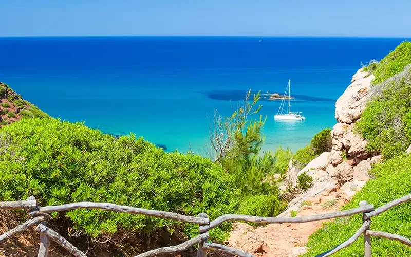
              5th stage: Cala Tirant – Cala Morell (20 km)

              This demanding stage crosses the roughest terrain of the north coast, passing by the virgin beach of Binimel-là and the lunar landscapes of Cala Pregonda, with its reddish islets. The trail continues between ravines and cliffs until it reaches the prehistoric necropolis of Cala Morell, with its burial caves carved into the rock.

              6th stage: Cala Morell – Ciutadella (15 km)

              The path descends to the west through areas of pine forest and Mediterranean scrubland to reach the unspoiled coves north of Ciutadella. The landscape becomes gentler as you approach the old capital of the island, whose historic center and medieval port are worth a visit.

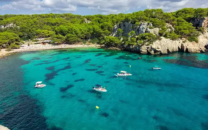
              7th stage: Ciutadella – Son Xoriguer (22 km)

              Leaving Ciutadella behind, the path enters the south coast, much more accessible and with white sand beaches and turquoise waters. It passes through emblematic coves such as Cala en Turqueta and Cala Macarella, of great scenic beauty, until it reaches the tourist area of Son Xoriguer.

              8th stage: Son Xoriguer – Santo Tomás (25 km)

              The longest stage runs along the south coast passing by some of the most famous beaches of Menorca such as Son Saura and Cala en Bosc. The landscape alternates medium height cliffs with extensive beaches, crossing also areas of Mediterranean forest and ravines until reaching Santo Tomás.

              9th stage: Santo Tomás – Cala en Porter (20 km)

              This section crosses some of the most spectacular ravines in the south of the island, such as the Barranc d’Algendar, with its vertical walls and rich vegetation. The trail passes near prehistoric Talayotic settlements before reaching the impressive Cova d’en Xoroi, carved into a cliff above Cala en Porter.

              10th stage: Cala en Porter – Maó (26 km)

              The last stage runs along the southeast coast through the beaches of Binisafúller and Binibèquer, with its characteristic white houses. The trail continues along the entrance to the estuary of Maó, passing by the islet of Lazareto and the fortress of La Mola, offering impressive views of the natural harbor before concluding the circular route in the city of Maó.

              This route allows you to discover the extraordinary landscape and cultural diversity of Menorca, combining nature, history and dream beaches in an accessible route for walkers in average physical condition.

              Menorca 8
              Coastal Path Menorca
              Menorca Cami de Cavalls 8 days - INDEPENDENT hiking trip

              Cami deCavalls South

              from 795 €
              6 stages of ◆Cami de Cavalls◆ Including luggage and persons transfers, maps, descriptions & GPX-files – Difficulty: ▲▲▲△△
              8 days
              Menorca Cami de Cavalls 10 | 12 days - INDEPENDENT hiking trip
              8 or 10 stages of ◆Cami de Cavalls◆ Including luggage transfers, maps, descriptions & GPX-files – Difficulty: ▲▲▲△△ | ▲▲▲▲△
              10 days