
28 Oct Walking trails on La Gomera
Walking trails on La Gomera
La Gomera is the second smallest island of the Canary Islands. The footpaths on La Gomera are perfectly signposted. The island also has a spectacular National Park: Garajonay. It was established in 1981 and subsequently declared a World Heritage Site by Unesco. This was the first National Park in the Canary Islands to achieve this status. Its laurel forest vegetation, a living relic of the Tertiary, covered the entire Mediterranean basin thousands of years ago. But it disappeared almost entirely during the successive glaciations. The laurel forest is a type of subtropical plant formation consisting of a huge mass of trees that retain their foliage all year round thanks to the high humidity. In the Garajonay National Park you can find fayas, heathers, laurels and giant ferns. This is a natural jewel dating from the Tertiary period. These are the laurel or laurel forests. The National Park can be easily explored by means of the numerous trails that cross it.
La Gomera was the last port of call for Christopher Columbus on his route to the New World. For this reason, this small Atlantic island is also known as the Isla Colombina.
Location and population of La Gomera
La Gomera is part of the Canary Islands archipelago and is located in the middle of the Atlantic Ocean. It is located in the western part and belongs to the province of Santa Cruz de Tenerife. Its capital is San Sebastián de La Gomera, also declared a World Heritage Site in 2009. The island of La Gomera has a population of 22,000 inhabitants. Its surface area does not exceed 370 km². La Gomera is influenced by the trade winds almost all year round. This type of wind, coming from the north-east, generates a constant flow of humidity through the so-called “sea of clouds”. The condensation of water vapour on the leaves of the trees considerably increases the amount of water on the ground.
The Gomeran whistle and the Almogrote
The inhabitants of La Gomera use a peculiar whistled language to exchange messages. This tradition comes from the past and allows them to communicate between the steep ravines. It is a unique language in the world, inherited from the island’s aborigines. And due to the peculiarities of its orography, it has been preserved over time and has been declared Intangible Cultural Heritage of Humanity. In terms of gastronomy, one of La Gomera’s delicacies is almogrote. Almogrote is made from cured goat’s cheese. It is a very thick sauce, ideal for spreading on bread with a good glass of wine.
The Descent of the Virgin on the trails of La Gomera
Every five years the descent of the Virgin of Guadalupe takes place. This festivity has its roots in antiquity and was established due to a crisis of faith of the population, which occurred in the historical past. The Virgin is taken from her sanctuary in Puntallana to the island’s capital, San Sebastián de La Gomera. This is the only fiesta in the Canary Islands where the Virgin is taken by sea. In this case, the paths on La Gomera are irrelevant as there is no pilgrimage.
Every year, when it is not a descent year, the so-called Fiesta de Puntallana is held.
Climate and Landscape of La Gomera
The climate of La Gomera is no different from that of the other western islands. The phenomenon of horizontal rainfall is fundamental for the Garajonay National Park. Moisture from clouds and mist is deposited on the trees, feeding the dense laurel forest. Temperatures remain stable throughout the year. And it is at its highest in the summer season. The thermometer is constantly between 19º and 23º C all year round.
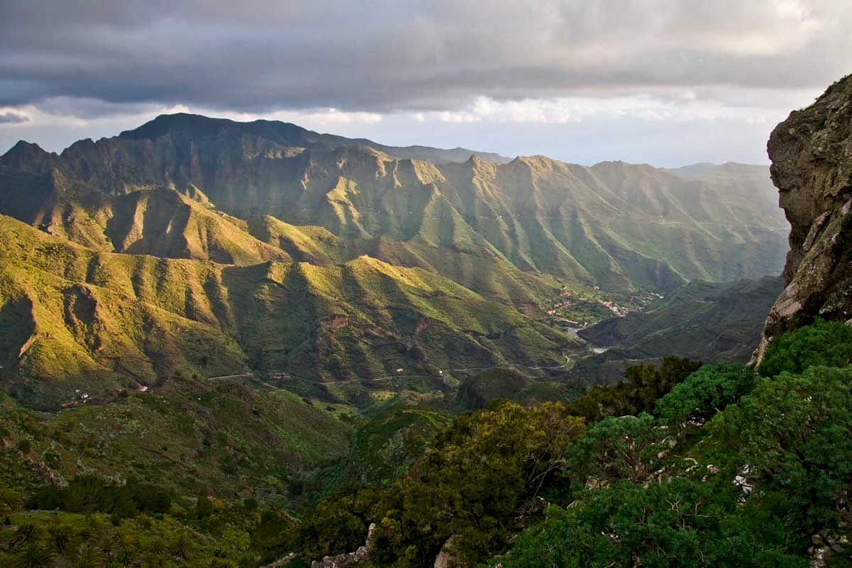
The impressive ravines are crossed by ancient trails on La Gomera. But the Garajonay National Park is located on the central plateau. The steep cliffs in the north retain the charm of a rugged landscape. And on clear days you can see the islands of La Palma, El Hierro and Tenerife from their high points.
Imposing rocks rise up between the ravines, forming a majestic landscape colonised by lush palm groves. On the coast, we can find tiny pebble beaches where the sea is rough and fierce. Such are the landscapes of La Gomera, which are interspersed with terraces of cultivated land that drop down from dizzying heights. Beautiful landscapes of perfectly arranged terraces between the beautiful farmhouses, which you will discover as you walk along the trails on La Gomera.
How to get to La Gomera
La Gomera can be reached by plane from Gran Canaria or Tenerife North. The airport is only suitable for local flights. The runway is short and international flights are not able to land. There are currently two airlines operating in La Gomera: Binter Canarias and CanaryFly. But the most comfortable way to reach La Gomera is, without doubt, by boat. From the south of Tenerife (Puerto de Los Cristianos), two shipping companies connect both islands with great frequency. Fred Olsen Express and Naviera Armas frequent the islands with modern ferries, connecting them in just 50 minutes. In addition, these ferry companies also maintain a direct connection with the island of La Palma.
Walking trails on La Gomera
There are more than 600 kilometres of footpaths that invite you to discover the island on foot. The trails in La Gomera allow us to enjoy the exuberant nature, with enormous trees and lush forests. The old paths have survived the passage of time and are the perfect place for hiking enthusiasts to enjoy. Whether in groups or individually, the experience of walking on the trails of La Gomera allows us to enjoy the beauty of this beautiful island. On our walking routes we will discover the charming hamlets, the traditional architecture and the rural atmosphere of the island. The trails through the Garajonay National Park reveal the magic of a fascinating and mysterious forest. With dream viewpoints and geological vestiges of a volcanic past. In La Gomera, the network of footpaths is excellent and well signposted.
What to see in La Gomera
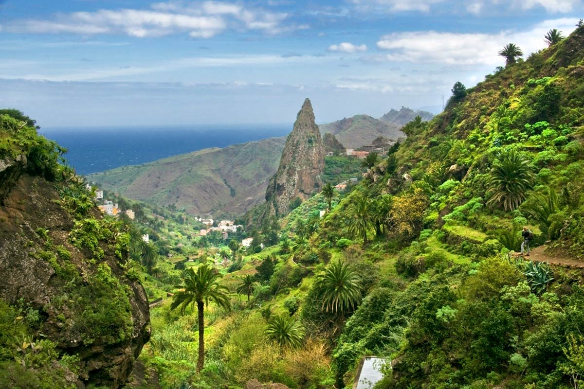
- The Garajonay National Park is undoubtedly one of the major attractions of La Gomera. As well as walking the trails in La Gomera, the imposing rocks are another of its many attractions. At the top of Garajonay, we can see three of the most imposing rocks: El roque de Agando, El roque de la Zarcita and El roque de Ojila. These are enormous volcanic rock masses, formed by the solidification of lava rappels before emerging to the surface. The islands of Tenerife, La Palma and El Hierro can also be seen from the Alto de Garajonay, at 1,487 metres above sea level. And on rare occasions you can even see the island of Gran Canaria in the distance.
- In the north is the Hermigua Valley. Together with Agulo, this territory constituted the territory of Mulagua in pre-Hispanic times. The entire north of La Gomera is a paradise of green terraces planted with banana trees. An area of peace and tranquillity that boasts the best climate in the world. The island’s capital, San Sebastián de La Gomera, is no more than 20 km away and slopes down from Garajonay to the sea, spilling into a green carpet of laurel forest.
- El Cedro. From El Cedro, the paths of La Gomera lead us to Hermigua, to die at the foot of the old Pescante, battered by the Atlantic. The Pescante is made up of concrete columns that recall a not-too-distant past of agricultural and economic splendour. The construction of this remarkable engineering work was carried out to provide an outlet for the export of tomatoes and bananas. The great agricultural landowners of the town, together with emigrants returning from Cuba, were the driving forces behind this engineering work.
- The villages of the north. El Cedro is home to some of the most impressive landscapes in the geography of La Gomera. A true hideaway of trees and paths, and one of the many reasons why La Gomera is known as the “Magic Island”. This is the perfect place for lovers of vegetation. With trees of twisted shapes and laden with moss. Their leaves fall in autumn and form a soft blanket that cushions the footsteps of hikers. The trails in La Gomera take us on a magnificent circular route, ascending from Hermigua to the El Cedro waterfall. Here we can admire this impressive 140 metre high waterfall.
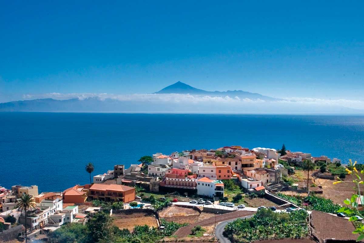
- Agulo, located in the beautiful north of La Gomera, is a rural corner full of charm and a haven of peace. Because of its beauty, it has been christened the “bonbon of La Gomera”. The whole village is like an immense viewpoint tinged by the green of its crops overlooking the Atlantic Ocean. It is a charming village with cobbled streets and idyllic little houses, cared for with great care and attention to detail. And on the cliff of Agulo there is a spectacular glass viewpoint from where you can observe the majestic Pico del Teide.
- The villages of the south. Valle Gran Rey is the main tourist destination for sun and beach lovers. There you will find El Charco del Conde, undoubtedly the best beach in Valle Gran Rey. It is a beach in the form of a natural pool with shallow water. It is well protected from dangerous currents. The beach is a paradise for families with children. But there are also other beaches, such as the famous Playa del Inglés. A beautiful black sandy beach a little away from the city centre, but with strong currents. And the Playa de Vueltas, located to the south of the municipality, next to the pier. An extensive beach, ideal for the whole family, which stands out for its fine black sand. The Plaza de la Ermita de San Antonio hermitage is a great viewpoint overlooking the palm grove of Valle Gran Rey. And on the Risco de la Merica there is a wild habitat where the giant lizard of La Gomera, an endemic reptile in danger of extinction, survives.
Walking trails on La Gomera
The extensive network of footpaths on La Gomera includes circular routes, linear paths and long-distance trails. The GR131 is a route around the island, ascending towards Garajonay. This is a route that takes several days and should be prepared in advance.