04 Jun Fisherman Trail Portugal
Fisherman Trail: step by step along the Portuguese coasts
The Fisherman Trail: a trail steeped in history.
The Fisherman Trail is one of the most spectacular and authentic routes in southern Portugal, following the Alentejo coastline. This coastal trail follows the old paths used by local fishermen, winding along imposing cliffs, unspoilt beaches and wild landscapes that form part of the Southwest Alentejo and Costa Vicentina Natural Park.
More than 200 kilometres long, the Fisherman Trail Portugal connects several coastal villages between Porto Covo and Odeceixe, offering an immersive hiking experience that combines natural beauty with Portuguese maritime culture. It is a demanding but accessible route, ideal for lovers of hiking, photography and nature.


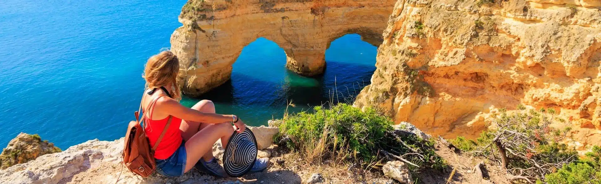
Imagine walking for hours with the Atlantic Ocean on your left, the constant sound of waves crashing against the cliffs, the smell of salt, and the wind blowing through low scrub and golden dunes. This is what it feels like to walk one of the most spectacular coastal paths in Europe, part of the famous Fisherman Trail in southwest Portugal. This trail is not just a hiking route: it is a deep immersion in the wild beauty and seafaring culture of the Alentejo and Algarve.


The Fisherman Trail Portugal follows in the footsteps of the ancient local fishermen, tracing a route from Porto Covo to Odeceixe, through more than 100 kilometres of pure unspoilt nature. Each section of the trail offers a different experience, from beaches hidden between cliffs to open landscapes where the native vegetation struggles to hold its ground against the constant wind from the sea.
The views are, quite simply, breathtaking: great cliffs plummeting into turquoise waters, rock formations sculpted by time and the ocean, and small coves where tourists barely reach.
But this trail is not just for the eyes. Here you walk with all your senses. In spring, the countryside explodes with wild flowers that fill the air with colour and fragrance. Birdsong accompanies the walk, and it is not uncommon to see ospreys or storks nesting on the cliffs.
The terrain, although challenging in some sections due to the loose sand or the unevenness, is perfectly passable for those who are used to walking. Of course, you should come prepared: good footwear, sun protection, water, and a great desire to be amazed.


One of the great advantages of the Fisherman Trail is that it connects small towns full of charm, such as Zambujeira do Mar, Vila Nova de Milfontes or Almograve, where the pace of life is calm, the food tastes of the sea and the people welcome the visitor with sincere hospitality. After a day’s walk, there is nothing better than a plate of fresh fish by the sea or a rest in a family guest house where everything invites you to relax.
Walking the Fisherman Trail Portugal is also an act of respect for nature. This route is designed for ecotourism, with clear signposting that avoids damage to the environment, and a route that is part of the GR11-E9, a major European trail linking the Atlantic with the Baltic Sea. Here, tourism does not invade, but accompanies: you walk without haste, you contemplate, you listen.
Natour Travel, with years of experience organising hiking in Portugal, takes care of every detail. In addition, they offer prior advice, personalised recommendations and routes tailored to your preferences: from more gentle and scenic routes to demanding stages for experienced hikers.
If you are looking for a different and profound way to discover Portugal, away from the crowds, this Fisherman Trail offers you a unique opportunity. Whether alone, as a couple or in a group, walking the Fisherman Trail is a gift of time, connection and silence.
For more information on self-guided programmes and customised packages, you can visit natour.travel and discover all the options available to live this adventure.
Stages of the Fisherman Trail
The route is divided into 13 well-marked stages. You can do the whole route in about 15 days, or choose just a few sections depending on your fitness level and availability.
Some recommended sections:
- Zambujeira do Mar to Odeceixe: One of the most beautiful stages of the Fisherman trail goes from Zambujeira do Mar to Odeceixe. Spectacular cliffs, secluded sandy coves and the picturesque natural harbour of Azenha do Mar make this section particularly impressive
- Porto Covo to Vila Nova de Milfontes: This is the beach stage, where you will walk along the long sandy beaches of Ilha do Pessegueiro, Aivados and Malhão and discover small deserted coves that will surprise you. It is considered a somewhat demanding but very rewarding route.
- Final stretch to Cabo de São Vicente: Last stage of this Fisherman Trail. We continue along dirt roads, with a view of the ocean on the horizon, surrounded by a vast expanse of bush fields. The lighthouse of Cabo São Vicente marks the most south-westerly point of Europe.
You can find full details of the stages on the Menorca tourism website or on the Natour Travel website, where you can also find out which sections to choose according to your profile.
Features of the Fisherman Trail
Complete Fishermen’s Trail: it always follows the sea along access roads to beaches and fishing grounds, for 125 kilometres, between Porto Covo and Cabo de São Vicente.
Historic Trail: 263 km covering lesser-known areas of the region. 13 one-day stages, each up to 25 km, except the stage from Sabóia to Odemira, which is 33 km long.
Remember that if you do the tour with a company like Natour Travel, you don’t have to worry about the logistics: they organise the transfers, they provide accommodation in selected places and they offer assistance in case of emergency.
Practical recommendations
You can plan your route according to your interests and physical preparation, but you should do one stage per day, with a maximum of 25 km. The stages are designed to be completed in one day each.
The coastal sections of the Fishermen’s Trail are generally considered the most spectacular for their ocean views, cliffs and pristine beaches, while the Historic Trail offers a more cultural experience through historic inland villages.
Best time to walk the Fisherman Trail
Between March and May, or between September and November. This way you can enjoy the perfect walking weather and avoid the large number of tourists present in high season in the coastal resorts.


Historical Origins of the Fisherman´s Trail
The paths that make up the Fisherman Trail largely follow the paths once used by fishermen to reach the best areas from which to set out by boat to fish. The Fisherman’s Trail follows in the footsteps of local fishermen, indicating that these routes have deep roots in the region’s maritime traditions.
Modern Development
Conceived as a public structure, the Fisherman Trail aims to assert itself as a defining characteristic of the region, making its use viable through hiking and contributing unequivocally to the sustainability of the rural world. The Fisherman Trail (Association for the Promotion of Nature Tourism in the Alentejo and Costa Vicentina) is a large network of hiking trails.
Structure of the Fisherman Trail
The Fisherman Trail is organised into two main trails:
1.-The Historic Trail (Caminho Histórico): it covers 263 km and shows rural areas rich in history. This route takes you through towns and villages with centuries-old histories, alongside rivers, streams and mountain ranges that blend nature and culture 5 tips for discovering the Fishermans Trail At 230 kilometres, it is the longest route that starts in Santiago do Cacém and ends at the emblematic Cabo de São Vicente Rota Vicentina.
2.- The Fishermen’s Trail (Trilho dos Pescadores): this is a linear itinerary that runs almost entirely along the coast and is entirely coastal.
Characeteristics and Location
The Fisherman Trail runs through the Algarve and Alentejo regions and hugs the western coast of the region. The trail ends at the most south-westerly point of Europe at Cape St. Vincent and Sagres.
The route has established itself as a perfect option for those seeking a unique hiking experience in Portugal, combining stunning natural landscapes, historical heritage and local gastronomy. Its development as a sustainable tourism project aims to boost rural economic activity while preserving the natural environment of this unique coastal region of Portugal.
Frequently asked questions
What is the difference between the Trilho dos Pescadores and the Caminho Histórico? The Trilho dos Pescadores runs along the coast, with stretches of sand and ocean views, while the Caminho Histórico goes further inland, passing through rural villages. Both are part of the Rota Vicentina.
What basic equipment do I need for hiking alone? Essential equipment includes: a suitable backpack, hiking boots, layered clothing, a map and compass or GPS, a first aid kit, sufficient water, energy-rich food, a torch or headlamp, an emergency whistle, and sun protection.
How do I choose the right route for my level of experience? Start with well-marked and popular trails, check the technical difficulty, distance and elevation gain, check the weather conditions, read reviews from other hikers, and always choose routes slightly below your limit when hiking alone.
What safety precautions should I take when hiking alone? Tell someone you trust about your route and estimated time, carry an emergency communication device, leave early to avoid darkness, stay on marked trails, trust your instincts if something doesn’t feel right, and have an escape plan.
How much water should I bring on a day hike? The general recommendation is 0.5-1 litre for every 2 hours of walking, plus extra for hot conditions or intense effort. For full-day routes, bring at least 2-3 litres, and consider purification systems if there are natural sources.
How do I navigate without getting lost on unmarked trails? Learn to use a topographic map and compass, mark important waypoints on your GPS, study the route beforehand, identify visual landmarks, and practise orientation techniques in familiar terrain before venturing out alone.
What do I do if I get lost during a hike? Stop immediately, stay calm, try to remember your last known location, use the STOP rule (Sit, Think, Observe, Plan), mark your current location, and if you cannot reorient yourself, stay where you are and call for help.
Is it safe to hike alone at night? Night hiking requires advanced experience, specialised equipment (powerful torches, extra batteries), prior knowledge of the trail, favourable weather conditions, and should only be done on familiar, well-marked routes.
How do I handle encounters with wildlife? Keep a safe distance, make preventive noise in bear areas, store food properly, do not feed animals, learn about local wildlife before you go, carry repellent spray if necessary, and back away slowly if you encounter large animals.
What mobile apps are useful for independent hiking? Recommended apps include AllTrails for routes and navigation, Gaia GPS for offline maps, What3Words for exact location, mountain-specific weather apps, and first aid apps. Always carry physical maps as a backup.
How do I physically prepare my body for long hikes? Build cardiovascular endurance gradually, strengthen your legs and core, practise with a loaded backpack, progressively increase distance and difficulty, include training on similar terrain, and maintain flexibility with regular stretching.
When should I cancel a planned trip? Cancel if there is severe weather, you feel ill or injured, trail conditions are dangerous, you have not informed anyone of your plan, your equipment is incomplete or damaged, or you simply do not feel mentally prepared.
How do I handle medical emergencies when I am alone? Carry a complete first aid kit and know how to use it, learn basic first aid, carry an emergency communication device, know your exact location, stay calm, assess the severity of the situation, and decide whether you can rescue yourself or need outside help.
What is the difficulty level of the Trilho dos Pescadores? It is moderately difficult, but some stages can be demanding due to the sandy terrain, sun and wind. Good physical condition and some hiking experience are recommended.
Is it necessary to book accommodation in advance? Yes, especially in high season (April-June and September-October). There are rural lodgings and hostels in most villages, but they fill up quickly.
What are the main sections of the Trilho dos Pescadores? The most popular stages are:
- Porto Covo – Vila Nova de Milfontes (20 km)
- Vila Nova de Milfontes – Almograve (15 km)
- Almograve – Zambujeira do Mar (22 km)
- Zambujeira – Odeceixe (18 km)
- And continue south to Carrapateira and Cabo de São Vicente.
What basic equipment do I need for hiking on this route?
- Lightweight backpack (30-40 L)
- Hiking boots or sturdy trainers
- Breathable and windproof clothing
- Hat and sunscreen
- Water (minimum 1.5-2 litres per stage)
- Snacks
- Map or offline GPS app
- Basic first aid kit
- Head torch
Is there signage along the route? Yes. The Trilho dos Pescadores is well marked with green and blue signs painted on posts or rocks. The forks in the trail are usually clear.
Can the route be done alone/safely? Yes, it is common to encounter other hikers, and the villages are relatively close by. However, it is important to let someone know your itinerary, carry a charged mobile phone and check the weather forecast.
What is the best season to walk this route?
▸Spring (March–May): Ideal weather and wild flowers.
▸Autumn (September–October): Pleasant temperatures and fewer tourists.
Avoid summer (July–August) due to the heat and lack of shade.
Is there public transport between the villages? Yes, although it is limited. There are buses between some towns, but they run infrequently. Consider local taxis or private transfers if you need to shorten stages.
Is it possible to camp freely along the route? Free camping is not allowed in most areas, especially in protected areas. It is best to stay in official accommodation.
Are there water sources or services along the way? There are few natural water sources. It is best to bring enough water with you at the start of each stage. You will find shops and cafés in the villages.
Is it advisable to use GPS or hiking apps? Yes, although the signage is good, having an app such as Wikiloc, Maps.me or AllTrails can help in confusing areas or if there is fog.
How long does it take to complete the entire route? The entire Trilho dos Pescadores (from Porto Covo to Cabo de São Vicente) is approximately 226 km and can be completed in 10 to 13 days, depending on your pace and number of breaks.
Are there any shorter or circular alternatives? Yes, there are circular sections and shorter routes within the Rota Vicentina, ideal for 1- or 2-day walks if you don’t want to do the entire route.